Pacific Plate
57
MENTIONS
19
EPISODES
15
PODCASTS
Search complete. 57 mentions across 19 episodes found for "Pacific Plate".
Nov 9, 2026

Jeffrey ZurekHOST
It's approximately 460 kilometers off the coast of Oregon.
Jeffrey ZurekHOST
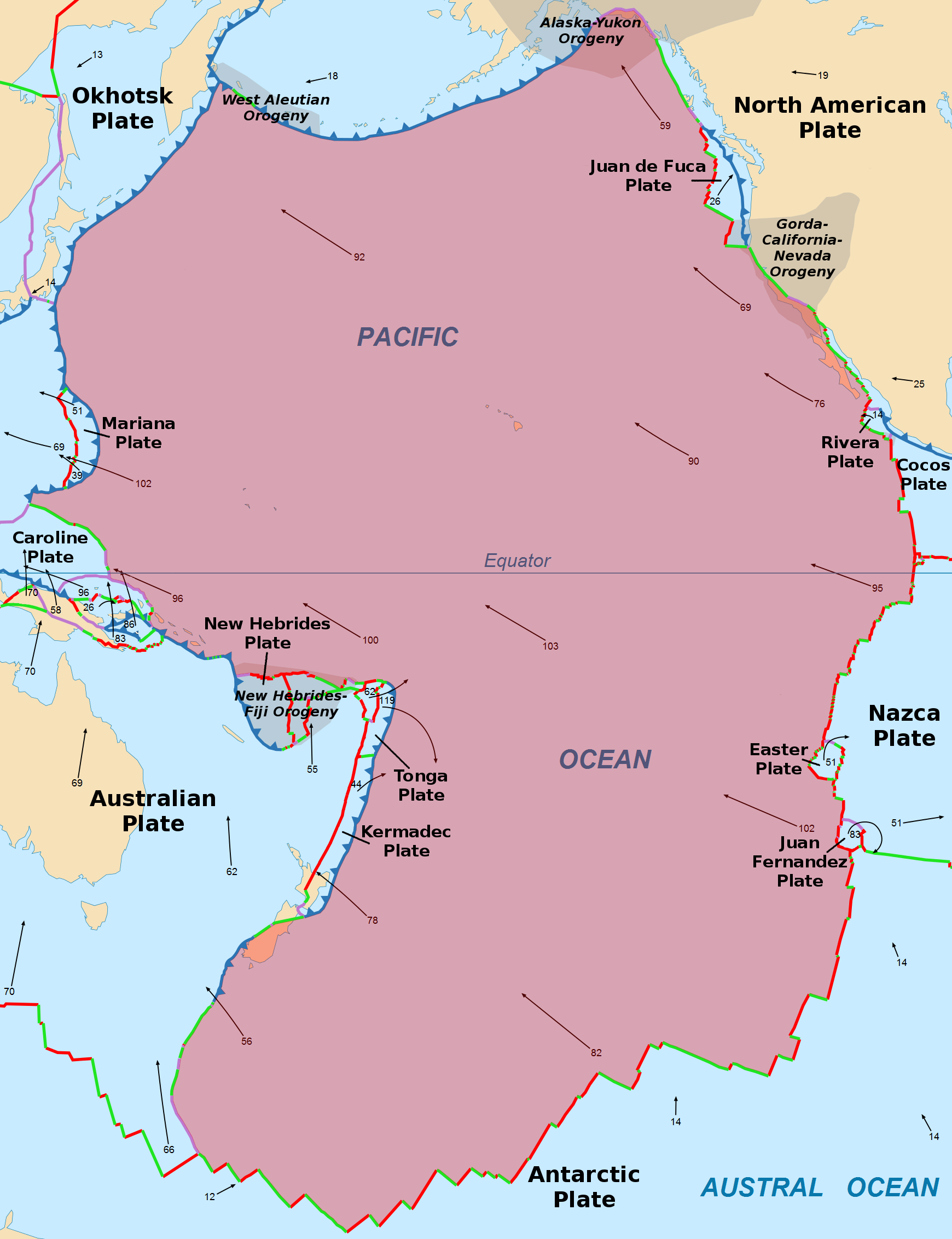
This volcano sits well beneath the waves, beneath the ocean, directly on top of the Juan de Fuca and Pacific Plate boundary.
Jeffrey ZurekHOST
Okay, well, most people don't exactly have a tectonic map in their heads ready to be brought up and rotated in three dimensions.
Jeffrey ZurekHOST
If a picture is worth a thousand words, A built auditory map is worth, well, I'm pretty sure it's still a thousand words, but delivered entirely through the soothing tones of my voice.
Jeffrey ZurekHOST
of the coast of North America, from British Columbia, Canada, through Washington State, Oregon State, and into Northern California, is the Cascadia subduction zone.
Jeffrey ZurekHOST
Here, small oceanic plates are being subducted or pushed beneath the North American plate.
Jeffrey ZurekHOST
So the Pacific Ocean roughly maps out the Pacific plate.
Jeffrey ZurekHOST
It's an oceanic plate made from denser rock than the continents, basaltic in nature, mafic, that it displaces more of the mantle and sits lower.

Claire ConcannonHOST
The interface between these two plates is complicated and changes along the length of the country.
Claire ConcannonHOST
But off the east coast of the North Island, the Pacific Plate dives under the Australian one in what's called the Hikarangi subduction zone.
Claire ConcannonHOST
This continues off the coast at the top of the South Island.
Claire ConcannonHOST
Along the length of the plate boundary, on either side of it, are crustal faults, basically stress fractures in Earth's crust, the topmost
Anna KaiserGUEST
Each big earthquake changes the stresses in the crust around and can have influence on the occurrence of the next earthquakes.
Claire ConcannonHOST
So a question they're working on is whether deeper faults play a role.
Claire ConcannonHOST
Remember the Hekarangi subduction zone that I mentioned, where the Pacific plate goes under the Australian plate?
Anna KaiserGUEST
That's actually New Zealand's biggest fault, but it's one that you can't see at the surface, but we know is there from our geophysical studies.

Rong-Gong Lin IIGUEST
It can take hundreds of years, but they're just waiting to move.
Rong-Gong Lin IIGUEST
And so you have the Pacific Plate.
Rong-Gong Lin IIGUEST
That's where L.A. is.
Rong-Gong Lin IIGUEST
wanting to go to the northeast.

speaker_0NARRATOR
The Alaska Range extends in both directions from Denali, a crescent of granite and ice stretching roughly four hundred miles from the Alaska Peninsula to the northeast toward the Canadian border.
speaker_0NARRATOR
It is a young range, geologically speaking, still being pushed upward by the collision of the Pacific Plate diving beneath the North American Plate along the great arc of the Aleutian Trench.
speaker_0NARRATOR
The mountains are still growing.
speaker_0NARRATOR
They gain a fraction of an inch per year, though erosion and glaciation claw back most of that gain, grinding the peaks down almost as fast as the tectonic forces push them up.
1 HR 46 MINS LATER
speaker_0NARRATOR
The mountains hold all interpretations simultaneously because the mountains do not interpret.
speaker_0NARRATOR
They simply are.
speaker_0NARRATOR
The range has stood for roughly sixty million years since the tectonic forces that drive the Pacific Plate beneath the North American Plate began pushing the sedimentary and volcanic rock of the coastal margin upward into the peaks that now define the southern skyline of interior Alaska.
speaker_0NARRATOR
In those sixty million years, the range has been glaciated and deglaciated multiple times.

Sean David MortonGUEST
And there's an area in the center of California that runs all the way from Sand Hills or what's called the Cargo Muchacho Mountains down by Yuma, Arizona, then runs up the center part of the state like a large boomerang up to Eureka, which is on the northern western coast of California.
Sean David MortonGUEST
And this area in the center is sort of like a large, muddy, adobe, almost kind of silly putty-like zone that actually acts as a crust or a fulcrum point between the Juan de Fuca Plate and the Pacific Plate.
Sean David MortonGUEST
Now, we've had, up until now, a lot of a very viscous fluid actually cushioning Southern California from a lot of these quakes.
Sean David MortonGUEST
And, of course, that was oil.
speaker_2NARRATOR
The Hadal zone was considered, for most of human history, to be a place beyond reach, a realm of such extreme pressure and such absolute darkness that nothing could survive there and no instrument could reach it.
speaker_2NARRATOR
There are fewer than 50 Hadal trenches on Earth, and they're distributed around the margins of the Pacific Ocean like the teeth of a jaw following the ring of fire, the horseshoe-shaped belt of tectonic activity where the Pacific plate and its neighbours are being consumed beneath the surrounding continental plates.
speaker_2NARRATOR
The trenches are narrow, typically between 40 and 100 kilometres across, and they are deep in a way that defies easy comparison.
speaker_2NARRATOR
The average depth of the ocean is 3,688 metres.
speaker_2NARRATOR
The Hadal Trenches begin where the average ocean floor ends and continue downward for another four to seven thousand meters into slots and depressions that have been carved into the Earth's crust by the grinding, bending and folding of tectonic plates over hundreds of millions of years.
speaker_2NARRATOR
The deepest of all is the Mariana Trench.
speaker_2NARRATOR
It lies in the western Pacific Ocean, approximately 200 kilometres east of the Mariana Islands, a chain of volcanic islands that mark the boundary where the Pacific Plate subducts beneath the younger, smaller Mariana Plate.
speaker_2NARRATOR
The trench is crescent-shaped, roughly 2,550 kilometres long, about 69 kilometres wide, and its deepest point, a slot-shaped depression called Challenger Deep, reaches 10,935 metres below the surface, plus or minus six metres.

Dianne EmersonHOST
Their outer shell is broken into enormous sections called tectonic plates, and that is where we're going to move this conversation away from, because I could get right now into a conversation about these tectonic plates and blah, blah, blah.
Dianne EmersonHOST
They have names for them, Pacific plate, North American plate, African plate, Eurasian plate, until our heads are spinning off, but I think that would only add to our confusion, because The measurement they're using, this MW thing, not the Richter scale, was developed during the 1970s.
Dianne EmersonHOST
Now it's the international standard.
Dianne EmersonHOST
It measures fault size, amount of movement, strength of the rocks, total energy release.
speaker_3NARRATOR
The Alaska Range extends in both directions from Denali, a crescent of granite and ice stretching roughly 400 miles from the Alaska Peninsula to the northeast toward the Canadian border.
speaker_3NARRATOR
It is a young range, geologically speaking, still being pushed upward by the collision of the Pacific Plate diving beneath the North American Plate along the great arc of the Aleutian Trench.
speaker_3NARRATOR
The mountains are still growing.
speaker_3NARRATOR
They gain a fraction of an inch per year, though erosion and glaciation claw back most of that gain, grinding the peaks down almost as fast as the tectonic forces push them up.
1 HR 47 MINS LATER
speaker_3NARRATOR
The mountains hold all interpretations simultaneously because the mountains do not interpret.
speaker_3NARRATOR
They simply are.
speaker_3NARRATOR
The range has stood for roughly sixty million years, since the tectonic forces that drive the Pacific Plate beneath the North American Plate began pushing the sedimentary and volcanic rock of the coastal margin upward into the peaks that now define the southern skyline of interior Alaska.
speaker_3NARRATOR
In those sixty million years, the range has been glaciated and de-glaciated multiple times.
9 more episodes mention Pacific Plate.
Create an account to see the whole feed, search across every transcript, and follow the entities you care about.