Mercator projection
165
MENTIONS
20
EPISODES
20
PODCASTS
Search complete. 165 mentions across 20 episodes found for "Mercator projection".
Oct 30, 2026

Jamie Arthur PickupGUEST
This is where he was shot, Meridian, Pennsylvania.
Jamie Arthur PickupGUEST
So when John Dee started to advise Queen Elizabeth and the British Empire, what he was using was Gerard-- Gerardus Mercator's meridian maps of longitude and latitude.
Jamie Arthur PickupGUEST
That's what it was all based on.
Jamie Arthur PickupGUEST
They were navigators of the seas.
Jamie Arthur PickupGUEST
They'd be vomiting off the blood and the guts and the gore that was taking form.
Jamie Arthur PickupGUEST
That's five hundred years ago, so imagine what they can do today on the world stage.
Jamie Arthur PickupGUEST
So Gerardus Mercator's meridian lines, why this is important.
Jamie Arthur PickupGUEST
So Gerardus Mercator's world map essentially is the atlas.

Annie FloraHOST
Question four.
Annie FloraHOST
The U.S. was the only no vote in a recent General Assembly vote to encourage governments to officially abandon what map projection in favor of equal area maps? Mercator.
Annie FloraHOST
The United Nations vote passed 164 to 1.
Annie FloraHOST
Two.
Annie FloraHOST
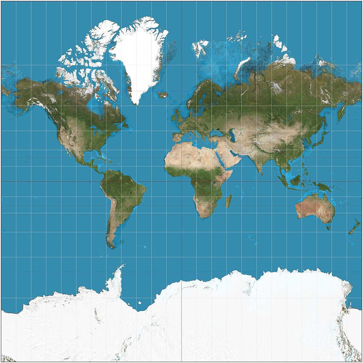
But yeah, I guess the Mercator projection inflates the size of lands the farther they are from the equator.
Annie FloraHOST
So that's why the sizes are wonky.
Annie FloraHOST
And we should change it away from that map.
Annie FloraHOST
But I did discover that the Mr. Mercator was a Flemish geographer.

IbrahimHOST
Yeah, that's what you do.
IbrahimHOST
For example, in the Mercator projection, which I will show you now, Greenland looks about the same size as Africa.
IbrahimHOST
Wait, let me make a note.
LouisHOST
Yeah, this is the photo that I was about to suggest.
LouisHOST
The photo of, not the Mercator projection, but the whatever it's called projection on the Mercator projection.
IbrahimHOST
Yeah, so...
IbrahimHOST
Greenland looks about the same size as all of Africa, which isn't really the case.
IbrahimHOST
Yeah.

Christopher DeanHOST
Also within her court, our producer, Gunner, reached out to me and sent some information.
Christopher DeanHOST
Mercator, from the Mercator projection map, which is the most common world map that we have, was also in the court of Queen Elizabeth I.
Christopher DeanHOST
No way.
Christopher DeanHOST
Yeah.
Christopher DeanHOST
So we've got John Dee, Sir Francis Bacon, Mercator.
Christopher DeanHOST
They are all the people that are surrounding Queen Elizabeth I.
Christopher DeanHOST
Okay.

Austin MayHOST
So that somehow reminds me of an old bit from West Wing where all of the cast members are assigned to just meet with some lobbying group just during one of the episodes.
Austin MayHOST
And there is this... map lobbying group who's like oh the mercator production which we all use which makes greenland huge and africa really small it's wrong yes what if we flipped it upside down what if south was north there's no real reason that north is north and south is south it's just you know the geomagnetic poles are there but it could be either way but what if antarctica was the top of the world it's just a different way of seeing literally the world and everything it's perspective that is the lesson in every debate we have every feud there is it's perspective
Patti VasquezHOST
right flip the ballot over because the person at the end of the ballot is more likely to be in your life than the person well i mean they are you just yes statistically you can run into them at the grocery store or a church or on the playground Just say, you ain't going to run into, you know, bless her, but you're less likely to run into soon to be elected Julianna Stratton, Senator Julianna Stratton.
Patti VasquezHOST
I'm just saying, you might run into her at an event, but not in line at the grocery store.

Heather HeyingHOST
Uh, can you see my screen? Awesome, you can show that now.
Heather HeyingHOST
The, the most famous, uh, map, uh, that we have is the Mercator projection, uh, which everyone, everyone has heard of that even if they don't know what it, what it means.
Heather HeyingHOST
This is, this is a version of the Mercator projection, and you can see even before I put up the little bullet points here.
Heather HeyingHOST
So a- and this is...
Heather HeyingHOST
All the maps I'm showing are from a, uh, Scientific American article that just came out yesterday called The Mathematical Impossibility of Making a Perfect World Map.
Heather HeyingHOST
Uh, and it's, and it's pretty good although their description of how each of the projections are made is a little bit too simplified so I'm not gonna go into it because it's, it's kind of mathematically complex.
Heather HeyingHOST
Um, but so a guy whose last name was Mercator, and so this came to be known as his projection, uh, developed in 1569 this projection.
Heather HeyingHOST
And very roughly speaking, like this isn't entirely accurate and it's very imprecise, but imagine if you have a piece of paper, uh, that you've, that you've like taped together at both ends to make a cylinder and you drop it over the globe such that the only place the, uh, the paper is touching the globe is the equator.

Miles GrebHOST
And then, you know, there's a contemporary illustration of it in 1836.
Trey the ExplainerHOST
I'm looking at the Mercator map and it has
Trey the ExplainerHOST
similar churches.
Trey the ExplainerHOST
No,
Miles GrebHOST
You don't like the American part.
Miles GrebHOST
I understand.
Trey the ExplainerHOST
I'm trying to get a good high-quality image of this Mercator map so I can prove this wrong, that they're all low-quality.
Miles GrebHOST
Okay, how about this one? You'll like this one.

Jean-Baptiste IsnardGUEST
It's a round globe.
Brett KingHOST
Yeah, the Mercator sizing of Africa-
Julia MichelinGUEST
Yeah
Brett KingHOST
... all that.

Tom WilliamsHOST
I'm Tom Williams.
Tom WilliamsHOST
The United Nations General Assembly recently voted overwhelmingly to endorse the Equal Earth projection map, which shows Africa and other equatorial regions in their true proportions instead of using the traditional Mercator projection.
Tom WilliamsHOST
The only nation voting against the resolution was the United States.
Tom WilliamsHOST
Our guest today is USU geography pr- professor Peter Howe.
Tom WilliamsHOST
This is Togolese Foreign Minister Robert Dussey.
Tom WilliamsHOST
He told Reuters, he said, "A fair world begins with a fair map." Then he told a UN briefing earlier, "A map is never neutral.
Tom WilliamsHOST
It shapes perceptions, influences how the place of peoples and continents in the world is understood." And, uh, then another, Lerato Mmogathlhe of Africa No Filter, a group behind this campaign to ditch the Mercator map, said, "Africa's misrepresentation on world maps is not just a cartographic error, it's a narrative issue." So I guess, uh, off the top, we'll get into, we'll get into the weeds, which have been pretty interesting to me to dive into, uh, uh, after this UN vote.
Tom WilliamsHOST
But maybe talk just a little bit at the top about, about this, the, the power of maps and, uh, a great narrative force.

Matt KirshenHOST
I'm sure I've snuck into some places that I shouldn't for emergencies.
Matt KirshenHOST
definitely done that by the way we have a clarification a correction from vincent from the last episode from ola saying uh straight lines on the mercator mercator protection are rumb lines lines of constant bearing so they're not in general great circles the shortest route they are uh constant bearing the equator Yeah, so they're not all great circles.
Matt KirshenHOST
They're just the lines of constant bearing, like direct, like a straight line on the thing.
Matt KirshenHOST
So lines of latitude are straight lines on the Mercator projection, but apart from the equator, lines of latitude are not great circles.
10 more episodes mention Mercator projection.
Create an account to see the whole feed, search across every transcript, and follow the entities you care about.