Lesser Antilles
Volcanic arcWikipedia
36
MENTIONS
29
EPISODES
25
PODCASTS
Search complete. 36 mentions across 29 episodes found for "Lesser Antilles".
Sep 14, 2026

Deb RobertsHOST
The National Hurricane Center is monitoring a disturbance in the central Atlantic.
Deb RobertsHOST
It's located more than 1,000 miles east of the Lesser Antilles and is moving westward.
Deb RobertsHOST
For now, forecasters say the chances of it developing are low, about 30%.
Deb RobertsHOST
The National Hurricane Center's Dr. Jack Bevin gave another prediction.

Verla VieiraNARRATOR
In later times, the islands between North and South America were generally called the Antilles, with the exception of the group known as the Bahamas.
Verla VieiraNARRATOR
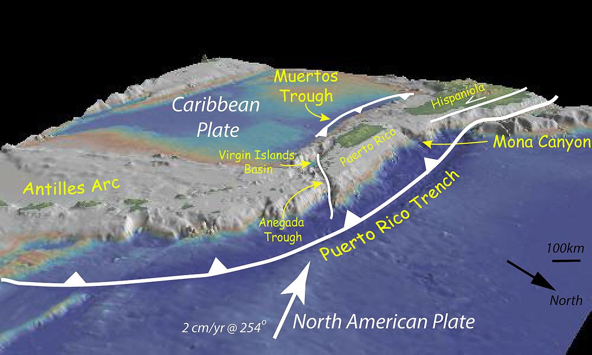
The four largest of the islands, Cuba, Haiti, Jamaica, and Puerto Rico, are distinguished as the Greater Antilles, the groups farther to the southeast, which embrace 26 islands in all, being known as the Lesser Antilles.
Verla VieiraNARRATOR
The Antilles form a sort of curved line from the entrance to the Gulf of Mexico, almost around to the mouth of the Orinoco River.
Verla VieiraNARRATOR
porto rico is at the large bend of the curve and is the most easterly and the smallest of the greater antilles haiti its next-door neighbor on the west is eight times as large and cuba occupies about space enough to hold an even dozen bodies of land of the size of porto rico we might think from this that porto rico is a small and insignificant island it is really however about three times as large as rhode island and is one of the most interesting regions that we hear anything about we shall find it quite worth our while to visit porto rico and we shall enjoy making acquaintance with the plants and animals and the people of this ambitious little island just north of the caribbean sea to reach it we must take a sail of fourteen hundred miles if we start from new york a five days voyage the island has been compared to various objects one writer has seen in its shape some likeness to an ox dressed and ready for market By a little play of imagination, we can easily trace the outlines of a human profile in the western coastline.

Verla VieiraNARRATOR
In later times, the islands between North and South America were generally called the Antilles, with the exception of the group known as the Bahamas.
Verla VieiraNARRATOR
The four largest of the islands, Cuba, Haiti, Jamaica, and Puerto Rico, are distinguished as the Greater Antilles, the groups farther to the southeast, which embrace 26 islands in all, being known as the Lesser Antilles.
Verla VieiraNARRATOR
The Antilles form a sort of curved line from the entrance to the Gulf of Mexico, almost around to the mouth of the Orinoco River.
Verla VieiraNARRATOR
porto rico is at the large bend of the curve and is the most easterly and the smallest of the greater antilles haiti its next-door neighbor on the west is eight times as large and cuba occupies about space enough to hold an even dozen bodies of land of the size of porto rico we might think from this that porto rico is a small and insignificant island it is really however about three times as large as rhode island and is one of the most interesting regions that we hear anything about we shall find it quite worth our while to visit porto rico and we shall enjoy making acquaintance with the plants and animals and the people of this ambitious little island just north of the caribbean sea to reach it we must take a sail of fourteen hundred miles if we start from new york a five days voyage the island has been compared to various objects one writer has seen in its shape some likeness to an ox dressed and ready for market by a little play of imagination we can easily trace the outlines of a human profile in the western coast-line the southwestern portion point aguila is the long square and prominent chin The deep depression forming the harbor of Mayaguez is the bold mouth, open as if about to speak.

Mark DykeshornNARRATOR
Weather Bureau.
Mark DykeshornNARRATOR
the american public has manifested a peculiar interest in the west indian hurricane of august seventh or fourteenth eighteen ninety nine this interest may be partially attributed to the fact that for the first time in our history the united states possessed territory in the tropics which was devastated and made temporarily dependent by a hurricane and aside from this consideration the storm afforded an opportunity for demonstrating the utility of the newly organized west indian branch of the united states weather bureau the experience of porto rico in this hurricane is of special interest and importance for the reason that she possessed the advantage of a full reporting station of the weather bureau from which warnings of the approach of the hurricane were disseminated the day before its arrival and where accurate data near the path at the center of the disturbance were recorded extending nearly four hundred miles east and southeast from porto rico are the leeward islands of the lesser antilles to the west of porto rico is the island of santo domingo north and distant about one hundred miles from the santo domingo coast are the easternmost islands of the bahama group which extend from the turks islands on the east about six hundred and fifty miles in a northwest direction to the west end of great bahama island which is seventy-five miles from the florida coast these islands border a line drawn northwest by west from guadalupe one of the southernmost islands of the leeward group over the bahamas a distance of fourteen hundred to fifteen hundred miles and this line represents the approximate path of the hurricane from august seventh to twelfth puerto rico records show that the usual path of hurricanes is somewhat to the south of that island and that during the last four hundred years the island has been visited by eight hurricanes which were attended by a marked loss of life or property the first of these occurred in july fifteen fifteen the second in fifteen twenty seven when the executive building in san juan was destroyed and the third on august twenty first sixteen fifteen when the cathedral was demolished the san juan news of august eighth eighteen ninety nine which contains this record states that the most violent hurricane in the history of porto rico occurred on the night of august twenty second seventeen seventy two it continued from eleven at night until three in the morning in alternating violent gusts and squalls trees were torn up by the roots fields were inundated plantations disappeared and a large number of people were killed and buried under the ruins of their houses on september fourth eighteen o six a hurricane caused great damage at ponce on september twenty first eighteen nineteen crops were damaged to such an extent that a famine followed a violent hurricane which is remembered by many present residents of the island occurred october twenty ninth eighteen sixty seven on august fourteenth eighteen eighty six a hurricane passed to the south of porto rico doing considerable damage along the south coast and destroying crops in the interior incubated in the warm and exceedingly moist region of equatorial rains the hurricane of august seventh or fourteenth eighteen ninety nine advanced toward the outlying islands of the leeward group during the night of august sixth its approach being first indicated by the eight a m reports of august seventh from the weather bureau stations at rousseau dominica and bastaire st christopher moving northwestward during the afternoon and night of the seventh the hurricane center apparently passed almost directly over guadalupe and montserrat and to the south of the virgin islands which are the extreme western islands of the leeward group the island of guadalupe suffered severely and on the island of montserrat nearly one hundred persons were reported killed and villages and estates were destroyed on the islands of nevis st christopher and antigua the storm was less severe while the danish island of st croix was the only one of the virgin islands which suffered to any great extent between eight and nine a m of august eighth the hurricane center passed over or very near the south coast of porto rico attended by an appalling loss of life and property and by the morning of the ninth had reached a position near the north coast of santa domingo following a west-northwest track the hurricane center arrived at the eastern bahamas and evidently passed near grand turk island during the night of the ninth the position and course of the storm during the succeeding twenty-four hours were approximately determined by the distant weather bureau stations of observation at santiago and porto principe cuba and by regular and special reports received through the cooperation of the colonial government at nassau bahamas by the morning of the eleventh there was evidence at nassau of the approach of the storm's center during the day the barometer fell rapidly with increasing northeast winds and heavy rain and during the evening cable communication between nassau and jupiter florida was lost On the following day, August 12th, the barometer fell rapidly at Jupiter, with wind increasing to a gale from the northeast, and by the morning of the 13th, the barometer at that station had fallen to 29.22 inches, and the wind had reached a velocity of 52 miles an hour.
Mark DykeshornNARRATOR
From the 14th to the 19th, the storm center drifted slowly northward and northeastward along the Atlantic coast, attended by severe gales and high seas from florida to virginia after which it apparently passed eastward over the ocean beyond the region of land observation with data now available it is not possible to determine the intensity of this hurricane at various points along its course during august seventh and eighth the character and extent of the destruction it caused will give it rank among the historical hurricanes of the leeward islands porto rico and santa domingo during the period it occupied in advancing from santa domingo over the bahama islands and thence northward off the atlantic coast of the united states no observations have been received which show the exact strength of the storm as measured by instrumental observations observations of this character made by shipmasters who encountered the hurricane will furnish data for a later and more exhaustive report in the meantime reports of disasters at sea are being multiplied and when the history of this hurricane is completed the casualties it caused on land and sea will aggregate hundreds of human lives and millions of dollars worth of property owing to the special interest taken in porto rico by the people of the united states and to the fact that this island possessed the only fully equipped and regular reporting station of the weather bureau which occupied a position in the path of the hurricane and near its centre an account in detail of the storm's characteristics will at this time be confined to data contained in instrumental records and reports rendered by the official in charge of the weather bureau office at san juan at san juan the barometer began to fall at ten p m of the seventh and the lowest recorded reading twenty nine point two three inches was reached at eight thirty a m of the eighth the wind was variable with occasional gusts during the night of the seventh and eighth and gradually settled into a gale from the north-east toward the morning of the eighth the hurricane was at its height at san juan between seven and nine a m of the eighth when the wind velocity was calculated by the weather bureau observer at eighty five to ninety miles an hour the observer reports that practically no thunder and lightning attended the storm only two flashes of lightning and they were not severe being observed by him the rainfall was very heavy a total of six point three seven inches falling of which four point eighteen inches fell from noon to eight p m of the eighth ponce and the port of ponce on the south coast were wrecked with a loss of about two hundred lives and an aggregate property loss of at least five hundred thousand dollars the estimated damage to property throughout the island is in the millions of dollars dwellings were destroyed and crops were ruined and the main body of the working population will be for a time dependent on the united states their home government for the necessities of life in conclusion it seems proper to refer to the action taken by the united states weather bureau in giving warning along the line of its advance of the approach of the hurricane center immediately upon the receipt of the morning reports of august seventh when the storm was central east of dominica the central office of the weather bureau at washington ordered through habana cuba hurricane signals from dominica to porto rico and the signals were carried to santa domingo the afternoon of the seventh messages containing information regarding the position and probable course of the hurricane were sent to all weather bureau stations in the west indies from barbados to cuba and as the hurricane moved westward signals were ordered and advices were telegraphed to all weather bureau stations in the threatened districts and to atlantic coast and gulf ports and there given the widest possible dissemination in fact the warnings for iran the storm by a period which varied from a few hours at the easternmost leeward islands to thirty six and forty eight hours at points along the south atlantic coast and gulf ports of the united states that the warnings were prompt accurate and of most incalculable value is universally acknowledged by owners and masters of vessels who by holding their vessels in port avoided a hurricane which by the evidence of disasters and reports of disasters was one of exceptional violence section three
Piotr NaterNARRATOR
section four of the national geographic magazine volume ten september eighteen ninety nine this is a libervox recording all libervox recordings are in the public domain For more information or to volunteer, please visit LibriVox.org. in the short article that appeared in the national geographic magazine for july i mentioned three obstacles that might stand in the way of mr wellman's success in his attempt to reach the ultimate north from the meagre accounts that have reached us it appears that all three of these hindrances were encountered a high latitude was not reached last year the greater part of the expedition spending the winter at or near the point of debarkation and only two members of the party advancing northward death carried away one of the best and strongest men and the leader himself was incapacitated by a serious accident and finally a breaking up of the ice on which they were encamped caused a loss of a considerable part of the equipment Fortunately, we are assured that some important discoveries were made in the neighbourhood of Freedom Island.

Jason DeCanioHOST
There are conflicting accounts of Verrazano's demise.
Jason DeCanioHOST
In one version, during his third voyage to North America in 1528, After he had explored Florida, the Bahamas, and the Lesser Antilles, Verrazzano anchored out to sea and rowed ashore, probably on the island of Guadalupe.
Jason DeCanioHOST
He was allegedly killed and eaten by the native Caribs.
Jason DeCanioHOST
The fleet of two or three ships was anchored out of gunshot range, and no one could respond in time.

Frank StraitPANELIST
The Gulf of whatever.
Frank StraitPANELIST
Over the Caribbean, there is a tropical wave moving across the Lesser Antilles.
Frank StraitPANELIST
No sign of organization there.
Frank StraitPANELIST
There's no significant thunderstorm activity with it, just some spotty stuff.

Jamie BeebeHOST
There's Fountain Cavern, an underground limestone cave containing a freshwater spring and ancient indigenous petroglyphs.
Jamie BeebeHOST
It's one of the most important pre-Columbian archaeological sites in the Lesser Antilles, although access is restricted to protect it, so this isn't somewhere you can just wander into with your flip-flops and a flashlight.
Jamie BeebeHOST
You can also visit Wall Blake House, built in the late 1700s, and the island's only surviving plantation house.
Jamie BeebeHOST
Explore old architecture around the valley, or go birding through Anguilla's salt ponds and wetlands.

LowkeyHOST
There you go with this stuff.
Josh ChristieHOST
Greater and Lesser Antilles.
Josh ChristieHOST
We all know who it is.
LowkeyHOST
Yeah.

Tom BradshawSOUNDBITE_SPEAKER
as we get into September.
Tom BradshawSOUNDBITE_SPEAKER
At the same time, we often get disturbances moving off of the West African coastline into what we call the main development region of the Atlantic, which is the area well to the east of the Lesser Antilles and the Greater Antilles.
Tom BradshawSOUNDBITE_SPEAKER
Unfortunately, this year, or fortunately, depending on your perspective, there's been a greater amount of wind shear than we normally see across the Atlantic Basin.
Tom BradshawSOUNDBITE_SPEAKER
And there's been a lot more dry air than what we normally see.

speaker_4UNKNOWN
It's
Manuel RamosGUEST
just east of the Lesser Antilles, so it's making its way.
Manuel RamosGUEST
It should reach at least moderate concentrations, should start reaching the area by around midnight to very early in the morning.
Manuel RamosGUEST
basically to start the month of September.
19 more episodes mention Lesser Antilles.
Create an account to see the whole feed, search across every transcript, and follow the entities you care about.