Labrador Current
CurrentWikipedia
9
MENTIONS
7
EPISODES
7
PODCASTS
Search complete. 9 mentions across 7 episodes found for "Labrador Current".
Sep 15, 2026

Zita CobbGUEST
And I think what's important is what are the specificities of a place? Because that's our actual strength, even though we rail against it when the winter is strong.
Zita CobbGUEST
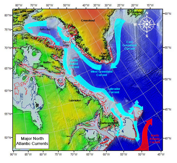
Fogo Island is a part of the North more than anything else because it's in the Labrador Current.
Zita CobbGUEST
And so the Labrador Current comes down from the west coast of Greenland.
Zita CobbGUEST
It is a cold, fast-moving current, and it has shaped the landscape of the island to look more like places much, much further north.
Zita CobbGUEST
It's classified as a subarctic landscape.

Sam WalkerHOST
We don't seem to have the experience of sea breeze.
Sam WalkerHOST
I know part of that's because you've got the collision of the Labrador Current and the Gulf Stream, and there's some stuff that goes on that way.
Sam WalkerHOST
Is there anything else besides that that kind of keeps, that prevents us from being seen in the sea breeze, or is it just where we are on the map and it just doesn't
Frank StraitPANELIST
happen? Well, you're just so far away from water, I mean, away from land, a big land mass where you are.

speaker_5NARRATOR
Indeed, considering only the amount of heat from 71 degrees to 50 degrees, it is still 275,000 times as great.
speaker_5NARRATOR
sweeping northward toward hatteras with its widening torrent its volume still further increased by new supplies drawn in from the bahamas and the northeast coast of cuba its color a liquid ultramarine like the dark blue of the mediterranean or of some deep mountain lake it then spreads north-eastward toward the grand banks of newfoundland and with decreasing velocity and lower temperature gradually merges into the general easterly drift that sets toward the shores of europe about the fortieth parallel the cold inshore current must also be considered because it is to great contrasts of temperature that the violence of storms is very largely due east of newfoundland the labrador current flows southward and during the spring and summer months carries gigantic icebergs and masses of field-ice into the tracks of transatlantic steamships upon meeting the gulf stream a portion of this cold current underruns it and continues on its course at the bottom of the sea another portion is deflected to the southwest and flows counter to the gulf stream along the coast as far south as Hatteras.
speaker_5NARRATOR
The broad features of these great ocean currents have thus been briefly outlined, and, although they are subject to considerable variation as to temperature, velocity, and limits in response to the varying forces that act upon them, this general view must suffice for the present purpose.
speaker_5NARRATOR
now to consider for a moment some of the phenomena resulting from the presence and relative positions of these ocean currents so far as such phenomena bear upon the great storm now under consideration with the pilot chart of the north atlantic ocean for march there was issued a supplement descriptive of waterspouts off the atlantic coast of the united states during january and february additional interest and importance had been given to the facts there grouped together and published by their evident bearing upon the conditions that gave rise to the tremendous increase of violence attendant upon the approach of this trough of low barometer toward the coast in it were given descriptions in greater or less detail of as many as forty water spouts reported by masters of vessels during these two months at various positions off the coast from the northern coast of cuba to the grand banks and since that supplement was published many other similar reports have been received.

Jason QuinnHOST
That is gnarly.
Matt NeriGUEST
Yeah, so you've got the warm Gulf Stream coming up from the south that meets the Labrador Current coming down from the Arctic, and it mixes off Newfoundland, and it creates some very fertile fishing grounds, but it also creates a lot of fog.
Matt NeriGUEST
It is statistically the foggiest place on Earth.
Matt NeriGUEST
Is it really? It is absolutely the foggiest place on Earth.

speaker_9NARRATOR
Suppose again that we convert the number of heat units thus obtained into units of work, so many foot-pounds, and thence ascertaining the corresponding horse-power, in order to compare it with something with which we are familiar.
speaker_9NARRATOR
considering only the portion of the gulf stream that flows between cape florida and the great bahama bank we find from the latest and most reliable data collected by the u s coast and geodetic survey that the area of cross section is ten point nine seven square miles geographic or sea miles of six thousand eighty six feet each mean velocity at this time of the year one point three zero five miles per hour mean temperature seventy one degrees fahrenheit these figures for mean velocity and temperature from surface to bottom are it will be noticed far below those for the surface current alone where the velocity is often as great as five knots an hour and the temperature as high as eighty degrees the indicated horse-power of a great ocean steamship la bourgogne werra umbria and city of new york for example is from nine thousand to sixteen thousand that of some modern vessels of war is still greater the vulcan now building for the british government is twenty thousand and the sardegua for the italian government twenty two thousand eight hundred again if we convert into its equivalent horse-power the potential energy of the two hundred seventy thousand cubic feet of water per second that rush down the rapids of niagara and make their headlong plunge of one hundred sixty feet over the american and horseshoe falls we get the enormous sum of five million eight hundred forty seven thousand the gulf stream however is every hour carrying north through the straits of florida fourteen and three tenths cubic miles of water more than three thousand times the volume of niagara equivalent considering the amount of heat it contains from seventy one degrees to thirty two degrees fahrenheit the three trillion and sixty three billion horse power or more than five hundred thousand times as much as all of these combined indeed considering only the amount of heat from seventy one degrees to fifty degrees it is still two hundred and seventy five thousand times as great sweeping northward toward hatteras with its widening torrent its volume still further increased by new supplies drawn in from the bahamas and the northeast coast of cuba its color a liquid ultramarine like the dark blue of the mediterranean or of some deep mountain lake it then spreads northeastward toward the grand banks of newfoundland and with decreasing velocity and lower temperature gradually merges into the general easterly drift that sets toward the shores of europe about the fortieth parallel the cold inshore current must also be considered because it is to great contrasts of temperature that the violence of storms is very largely due east of newfoundland the labrador current flows and during the spring and summer months, carries gigantic icebergs and masses of field ice into the tracks of transatlantic steamships.
speaker_9NARRATOR
Upon meeting the Gulf Stream, a portion of this cold current underruns it and continues on its course at the bottom of the sea.
speaker_9NARRATOR
Another portion is deflected to the southwest and flows counter to the Gulf Stream along the coast as far south as Hatteras.

speaker_7NARRATOR
Considering only the portion of the Gulf Stream that flows between Cape Florida and the Great Bahama Bank, we find from the latest and most reliable data collected by the U.S. Coast and Geodetic Survey that the area of cross-section is 10.97 square miles, geographic or sea miles of 6,086 feet each.
speaker_7NARRATOR
mean velocity at this time of the year 1.305 miles per hour mean temperature 71 degrees fahrenheit these figures for mean velocity and temperature from surface to bottom are it will be noticed far below those for the surface current alone where the velocity is often as great as five knots an hour and the temperature as high as eighty degrees the indicated horsepower of a great ocean steamship la burgogne guerra umbria and city of new york for example is from nine thousand to sixteen thousand that of some modern vessels of war is still greater the vulcan now building for the british government is twenty thousand and the sardegua for the italian government twenty two thousand eight hundred again if we convert into its equivalent horsepower the potential energy of the two hundred seventy thousand cubic feet of water per second that rush down the rapids of niagara and make their headlong plunge of one hundred sixty feet over the american and horseshoe falls we get the enormous sum of five million eight hundred forty seven thousand the gulf stream however is every hour carrying north through the straits of florida fourteen and three tenths cubic miles of water more than three thousand times the volume of niagara equivalent considering the amount of heat it contains from seventy one degrees to thirty two degrees fahrenheit to three trillion and sixty three billion horsepower or more than five hundred thousand times as much as all of these combined indeed considering only the amount of heat from seventy one degrees to fifty degrees it is still two hundred and seventy five thousand times as great sweeping northward toward hatteras with its widening torrent its volume still further increased by new supplies drawn in from the bahamas and the northeast coast of cuba its color a liquid ultramarine like the dark blue of the mediterranean or of some deep mountain lake it then spreads northeastward toward the grand banks of newfoundland and with decreasing velocity and lower temperature gradually merges into the general easterly drift that sets toward the shores of europe about the fortieth parallel the cold inshore current must also be considered because it is to great contrasts of temperature that the violence of storms is very largely due east of newfoundland the labrador current flows southward and during the spring and summer months carries gigantic icebergs and masses of field ice into the tracks of transatlantic steamships upon meeting the gulf stream a portion of this cold current underruns it and continues on its course at the bottom of the sea another portion is deflected to the southwest and flows counter to the gulf stream along the coast as far south as hatteras the broad features of these great ocean currents have thus been briefly outlined and although they are subject to considerable variation as to temperature velocity and limits in response to the varying forces that act upon them this general view must suffice for the present purpose now to consider for a moment some of the phenomena resulting from the presence and relative positions of these ocean currents so far as such phenomena bear upon the great storm now under consideration with the pilot chart of the north atlantic ocean for march there was issued a supplement descriptive of water spouts off the atlantic coast of the united states during january and february additional interest and importance have been given to the facts there grouped together and published by their evident bearing upon the conditions that gave rise to the tremendous increase of violence attendant upon the approach of this trough of low barometer toward the coast in it were given descriptions in greater or less detail of as many as forty water spouts reported by masters of vessels during these two months at various positions off the coast from the northern coast of cuba to the grand banks and since that supplement was published many other similar reports have been received moreover it was pointed out that the conditions that gave rise to such remarkable and dangerous phenomena are due to the interaction between the warm moist air overhanging the gulf stream and the cold dry air brought over it by north-westerly winds from the coast and from over the cold inshore current and the greater the differences of temperature and moisture the greater the resulting energy of action reports were also quoted showing that the gulf stream was beginning to reassert itself after a period of comparative quiescence during the winter months and with increasing strength and volume was approaching its northern limits as the sun moved north in declination such then were the meteorological conditions of the coast awaiting the attack of the advance guard of this long line of cold north-westerly gales conditions still further intensified by the freshening gale that sprung up from the south-east at its approach drawing reinforcements of warm moist ocean air from far down within the tropics the energy developed when storm systems of only ordinary character and severity reached the atlantic on their eastward march toward northern europe is well known and need not be referred to further
Margaret EspayatNARRATOR
furtherLet us now return to the consideration of this storm, which is advancing toward the coast at the rate of about six hundred miles a day, in the form of a great arched squall, whose front is more than a thousand miles in length, and which is followed, far down the line, by northwesterly gales and temperatures below the freezing point.
Margaret EspayatNARRATOR
End of section five.